
 |
|
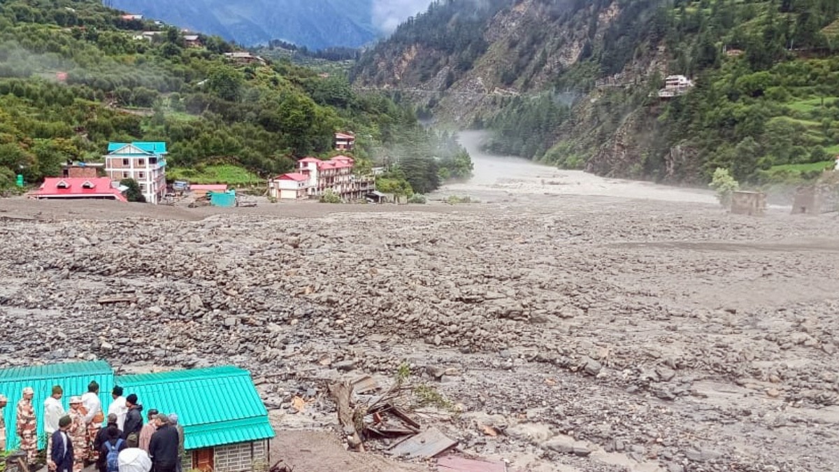
The state of Uttarakhand, nestled within the Himalayas, finds itself perpetually grappling with the destructive forces of nature. The recent cloudburst near Gangotri, which ravaged Dharali village, serves as yet another stark reminder of the region's vulnerability to a cascade of calamities, including cloudbursts, flash floods, landslides, avalanches, and land subsidence. This pattern of devastation has persisted for over two decades, raising critical questions about the underlying causes and the efficacy of existing mitigation strategies. The devastating Kedarnath floods of 2013, triggered by the breaching of a Himalayan glacial lake, resulted in the tragic loss of over 6,000 lives. More recently, in 2021, an avalanche in Chamoli inflicted significant damage on a crucial hydropower project, while flash floods in Uttarkashi swept away numerous villages. The monsoon season of 2023 witnessed nearly 100 deaths attributable to landslides, and earlier in the same year, Joshimath reported alarming levels of land subsidence. Last year alone, the state documented over 1,800 landslide incidents during the monsoon season, painting a grim picture of the region's susceptibility to geological instability. The August 5th cloudburst in Uttarkashi unleashed a torrent of flash floods and massive landslides, instantaneously engulfing homes, shops, hotels, and properties along the Dhauli Ganga river. The disaster claimed the lives of at least five individuals, with over 100 people reported missing. Dharali, the epicenter of the destruction, is situated within the Bhagirathi Eco-Sensitive Zone, highlighting the delicate ecological balance of the area and the potential consequences of unchecked development. Experts suggest that construction activities on river floodplains and other unsustainable practices may have amplified the severity of the calamity. These recurring incidents are not isolated events but rather indicative of a deeper, long-neglected crisis. Uttarakhand's unique geographical characteristics, coupled with the manner in which they are being managed, render the state particularly susceptible to natural disasters. The fundamental question is no longer whether disasters will occur but rather why they are striking with such frequency and intensity.
According to the 2023 Landslide Atlas of India, compiled by the Indian Space Research Organisation (ISRO), India ranks as the fourth most vulnerable country in the world to landslide risk, with a concerning average of more than one death per 100 square kilometers reported annually. The majority of landslides in India occur during the monsoon months, spanning from June to September. The country alone accounts for a staggering 16 percent of all rainfall-related landslides globally. These landslides are triggered by a combination of natural factors, such as heavy rainfall, the weakening of rock formations, and seismic activity, as well as anthropogenic activities, including construction and mining operations. Landslides manifest in various forms, including debris flows, rockfalls, and slides, and can be triggered by a range of factors, such as rain, erosion caused by floods, earthquakes, snowmelt, and human activities like overgrazing, deforestation, and unplanned development. In Uttarakhand, the confluence of these factors creates a highly conducive environment for such disasters to occur. The 2023 Landslide Atlas includes a comprehensive landslide exposure analysis for 147 districts across 17 states and two Union territories in India's mountainous regions, based on key socioeconomic parameters. Rudraprayag district in Uttarakhand, which exhibits the highest landslide density in the country, also ranks highest in terms of exposure to population and the number of houses. Tehri Garhwal is ranked second, further highlighting the acute vulnerability of the region. Other Uttarakhand districts featured in the top 25 include Chamoli (19th), Uttarkashi (21st), and Pauri Garhwal (23rd), underscoring the widespread nature of the problem across the state.
Charu C. Pant, a retired professor of geology and former dean in the faculty of science at Kumaun University, Nainital, emphasizes the crucial role of the Great Himalayan Granite stone in the geological instability of the region, particularly within the Main Central Thrust zone, which constitutes one of the most active and critical fault lines in the Himalayas. Uttarakhand encompasses both the Lesser and Greater Himalayas, and the zone where these two ranges converge is known as the Main Central Thrust. This zone, which extends across northern India to Arunachal Pradesh, is characterized by its fragility. The Great Himalayan Granite body, emplaced deep within the earth's crust approximately 20-25 million years ago, forms part of the Greater Himalayan Sequence, a key tectonic unit of the Himalayas, and sits directly above the Main Central Thrust. As the Indian plate continues to collide with the Eurasian plate at a rate of 55 millimeters per year, the granite mass acts as a hard, brittle block caught between two tectonic forces. According to experts, the pressure and heat generated along this fault line induce intense deformation in the surrounding rocks. However, granite itself is relatively rigid and does not readily absorb stress. Instead, the energy is transferred to the adjacent rocks, which are already fractured from previous tectonic activity. These rocks gradually become crushed, sheared, and pulverized. Consequently, the presence of this hard granite in a tectonically active zone acts as a wedge that grinds and weakens the surrounding rocks. Over time, this process has created a deeply fractured and unstable zone along the Main Central Thrust, making it highly susceptible to landslides, rockfalls, and rapid erosion, particularly during periods of heavy rainfall or seismic activity.
Pant further explains that the narrow valleys through which the rivers flow exacerbate the problem. The water-bearing clouds that form over these valleys become trapped between the tall, steep mountains, leading to intense precipitation and often resulting in cloudbursts. These cloudbursts trigger landslides, and the heavy water, mixed with mud, stones, and other debris, flows rapidly downhill, causing widespread devastation. These debris flows possess a high erosive power due to the solid elements they carry, further compounding the damage. The impact of western disturbances, weather systems originating over the Mediterranean Sea and traveling eastward across Iran, Afghanistan, and Pakistan before reaching northern India, can further exacerbate the situation. These disturbances bring moisture that often results in winter rain and snow in the Himalayan region. When combined with the monsoon, the intensity of rainfall increases, further increasing the risk of landslides and flash floods. While these natural phenomena are not new, the unprecedented construction in the Himalayan region, including construction on riverbeds, as well as rising population and human activity, significantly complicate the situation. For example, at least 12 large or small hydel projects are currently in various stages of planning or approval in Uttarakhand. Similarly, the Rs 12,000 crore Char Dham Highway project, which involves the widening of approximately 900 kilometers of roads, has been embroiled in controversy since its approval in 2016 due to the numerous mishaps associated with it.
With this increasing pressure, natural calamities are causing far greater damage than before. As Dharali in Uttarkashi mourns its dead and prays for the missing, Pant stresses that governmental intervention must extend beyond relief and rehabilitation efforts for individual tragedies. He emphasizes the need for a stringent policy that prohibits construction on riverbeds and enforces the recommendations of environmental assessments for development projects without any undue pressure. In essence, he calls for a fundamental revision of the existing rules and regulations and strict adherence to them.
Source: Dharali cloudburst: Why Uttarakhand faces nature's fury so frequently