
 |
|
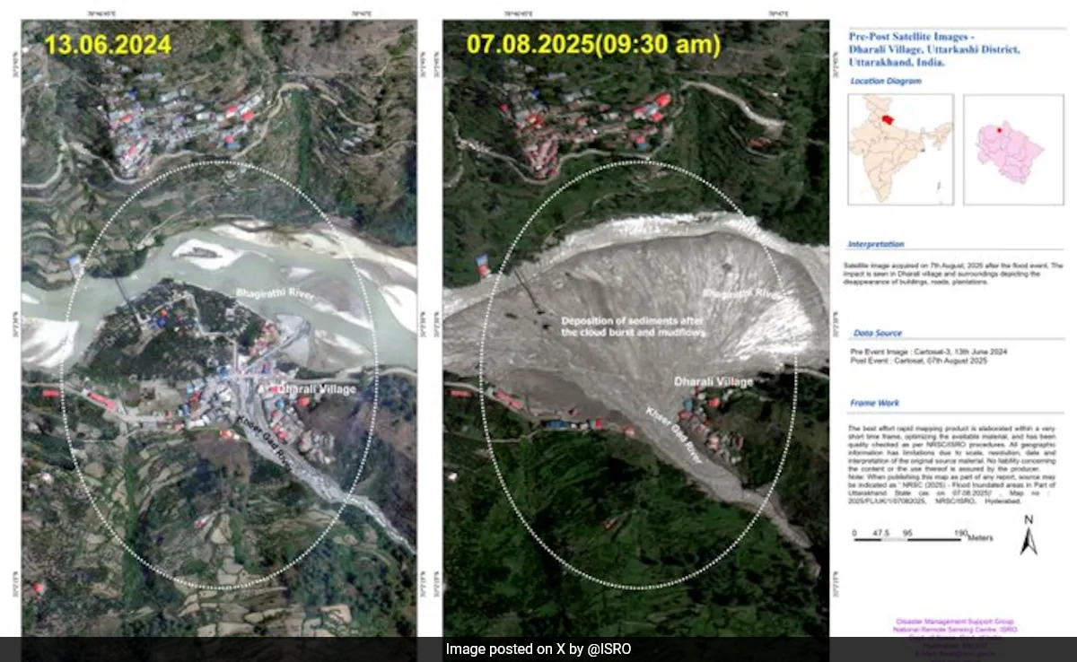
The recent flash floods and landslides in Uttarakhand's Uttarkashi district have caused widespread devastation, particularly in the Dharali village area. The Indian Space Research Organisation (ISRO) has provided critical insights into the extent of the damage through satellite imagery, highlighting the dramatic changes to the landscape before and after the disaster. These images vividly illustrate the power of the natural forces at play and the vulnerability of human settlements in the face of such events. The visual evidence provided by ISRO is not just a testament to the destructive impact of the floods but also a crucial tool in aiding rescue and relief efforts. The ability to assess the damage remotely, identify flooded areas, and map altered river paths has been invaluable in guiding rescue teams to prioritize their efforts and reach those most in need. This underscores the importance of space-based technologies in disaster management and the role they can play in mitigating the impact of natural calamities. The images released by ISRO depict a scene of utter devastation. What was once a small patch of land along the Bhagirathi River, dotted with houses, orchards, and small buildings, has been completely submerged. The river's course has been altered, and a massive deposit of sediment and debris, measuring approximately 20 hectares, has been dumped in the area. The Kheer Gad River, a tributary of the Bhagirathi, has also wreaked havoc, washing away roads and bridges. The interior parts of Dharali village have been particularly hard hit, with entire sections of the settlement obliterated by the floodwaters. The impact of the floods is not limited to the immediate area around Dharali. The images also reveal the extent of the damage to infrastructure, including roads and bridges, which are essential for connecting remote communities and delivering aid. The destruction of these lifelines has further complicated the rescue and relief efforts, making it difficult to reach affected areas and provide assistance to those who have been displaced or injured. The ISRO satellite images provide irrefutable evidence of the scale of the disaster and the urgent need for comprehensive relief efforts. They serve as a stark reminder of the vulnerability of communities living in mountainous regions, where natural disasters such as flash floods and landslides are a constant threat. The information gathered from these images is not only crucial for immediate rescue and relief operations but also for long-term planning and mitigation efforts. By understanding the causes of the floods, the patterns of water flow, and the vulnerability of different areas, it is possible to develop strategies to reduce the risk of future disasters and protect communities from their devastating impact.
The immediate aftermath of the disaster saw a massive rescue and evacuation operation, with officials working tirelessly to reach those who were stranded or injured. According to news reports, nearly 1,300 people were rescued and/or evacuated from the affected areas. The Garwhal Commissioner, Vinay Pandey, confirmed that rescue operations had been closed and that road connectivity had been largely restored. Essential supplies, including food, warm clothing, and daily necessities, were being distributed to those in need. However, the search for missing persons continued, with 43 people, including nine Army personnel, still unaccounted for. The efforts to locate the missing individuals were hampered by challenging terrain, inclement weather, and the sheer scale of the devastation. The identification of missing Nepali workers also presented a challenge, with discrepancies in the initial reports. Despite these difficulties, officials remained committed to providing updates and assistance to the families of the missing. The tragedy in Uttarakhand underscores the importance of preparedness and early warning systems in mitigating the impact of natural disasters. While the precise timing and intensity of such events may be difficult to predict, it is possible to identify areas that are at high risk and implement measures to reduce the vulnerability of communities living in those areas. This includes building resilient infrastructure, developing evacuation plans, and educating residents about the risks they face. Furthermore, it is essential to invest in monitoring and forecasting systems that can provide early warnings of impending disasters, allowing people to evacuate to safety before the worst of the event strikes. The ISRO satellite images have played a crucial role in the rescue and relief operations, providing valuable information to guide search teams and assess the extent of the damage. However, it is important to recognize that satellite imagery is just one tool in a larger toolkit. Effective disaster management requires a multi-faceted approach that includes ground-based observations, local knowledge, and community participation. By combining these different sources of information, it is possible to develop a more comprehensive understanding of the risks and vulnerabilities that exist in different areas.
The response to the Uttarakhand floods has highlighted the importance of coordination and collaboration between different agencies and organizations. The involvement of the Indian Army, the National Disaster Response Force (NDRF), local authorities, and non-governmental organizations (NGOs) has been essential in ensuring that aid reaches those who need it most. However, there is always room for improvement in terms of communication, coordination, and resource allocation. In the aftermath of a disaster, it is crucial to have clear lines of authority and well-defined protocols for responding to the crisis. This includes establishing a central command center, coordinating rescue and relief efforts, and ensuring that information is shared effectively among all stakeholders. It is also important to have adequate resources available to respond to disasters, including trained personnel, specialized equipment, and emergency supplies. These resources should be strategically located throughout the country to ensure that they can be deployed quickly and effectively when needed. The long-term recovery from the Uttarakhand floods will require a sustained effort from all levels of government, as well as the support of the international community. This includes rebuilding damaged infrastructure, providing financial assistance to affected families, and supporting the restoration of livelihoods. It is also important to address the underlying causes of vulnerability, such as poverty, inequality, and environmental degradation. By investing in sustainable development and promoting resilient communities, it is possible to reduce the risk of future disasters and create a more secure and prosperous future for all. The weather forecast indicated continued rain in the region, with a 'yellow' alert issued for all districts and a 'red' alert for heavy to very heavy rain in several districts. This poses a further challenge to the recovery efforts and highlights the ongoing vulnerability of the region to natural disasters. The combination of immediate disaster response and long-term recovery planning is vital for ensuring community resilience. The events in Uttarakhand serve as a cautionary tale about the vulnerability of human settlements to natural disasters, especially in the context of climate change. As the global climate continues to warm, extreme weather events such as floods, droughts, and heatwaves are likely to become more frequent and intense. It is therefore essential to take proactive steps to reduce greenhouse gas emissions and adapt to the changing climate. This includes investing in renewable energy, promoting energy efficiency, and implementing sustainable land management practices.
Furthermore, the international community has a responsibility to support developing countries in their efforts to adapt to climate change. This includes providing financial assistance, technology transfer, and capacity building. By working together, we can create a more resilient and sustainable future for all. The disaster in Uttarakhand should serve as a wake-up call, reminding us of the urgent need to address the climate crisis and build more resilient communities. The lessons learned from this tragedy can help us to prepare for future disasters and protect vulnerable populations from their devastating impact. The role of technology in disaster management is continually evolving. The use of drones for damage assessment, the application of artificial intelligence for predictive modeling, and the development of mobile apps for emergency communication are just a few examples of how technology can be used to improve disaster response. Continued investment in research and development is essential to ensure that we have the tools and technologies we need to protect communities from the growing threat of natural disasters. The focus should be on creating integrated systems that combine data from multiple sources, including satellites, ground-based sensors, and social media, to provide a comprehensive picture of the situation on the ground. These systems should be designed to be user-friendly and accessible to all stakeholders, including emergency responders, government officials, and the general public. The long-term impacts of the Uttarakhand floods are likely to be significant. The destruction of homes, infrastructure, and agricultural land will have a devastating effect on the local economy. The displacement of communities will lead to social disruption and psychological trauma. The loss of lives will leave a lasting void in the hearts of families and communities. It is therefore essential to provide comprehensive support to those who have been affected by the disaster, including financial assistance, counseling services, and job training. The focus should be on helping people to rebuild their lives and restore their livelihoods. The importance of community-based disaster preparedness cannot be overstated. Local communities are often the first responders in a disaster, and their knowledge and experience can be invaluable in saving lives and minimizing damage. It is therefore essential to empower communities to prepare for disasters by providing them with training, resources, and information. This includes developing evacuation plans, establishing community emergency response teams, and stocking up on essential supplies.
Source: ISRO Pics Show Impact Of Floods On Uttarakhand's Dharali, Bhagirathi River