
 |
|
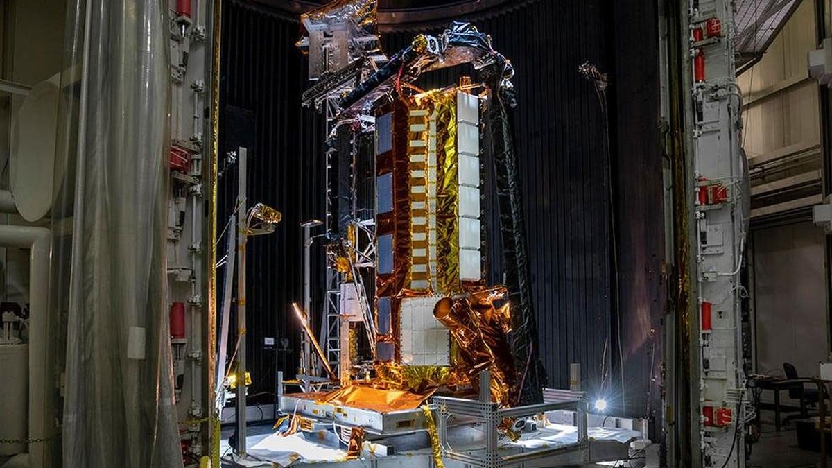
The successful launch of the NASA-ISRO Synthetic Aperture Radar (NISAR) satellite marks a pivotal moment in Earth observation and international space collaboration. This joint mission, a testament to the synergistic potential of two leading space agencies, promises to revolutionize our understanding of Earth's dynamic processes and provide invaluable data for climate resilience, disaster management, and a host of commercial applications. The core innovation of NISAR lies in its dual-frequency radar system, utilizing both L-band radar from NASA and S-band radar from ISRO. This unique configuration allows for continuous monitoring of the Earth's surface with unparalleled precision, capturing even minute changes at a scale of less than a centimeter across areas roughly half the size of a tennis court. This capability unlocks a wealth of scientific opportunities previously unattainable with existing Earth observation satellites. The interview with Karen St. Germain, Director of the Earth Science Division at NASA, provides valuable insights into the mission's objectives, challenges, and potential impact. She emphasizes the satellite's ability to detect subtle movements and structural changes in a wide range of environments, from forests and buildings to glaciers and mountains. This includes detecting the subtle bulging that precedes volcanic eruptions, identifying unstable land before landslides, and assessing building shifts after earthquakes. The ability to monitor forest cover changes resulting from deforestation is another crucial application, particularly in the context of climate change and biodiversity conservation. The data collected by NISAR will be instrumental in enhancing climate resilience by providing detailed information on ice-sheet dynamics, land deformation, and forest biomass. This information is critical for understanding the impacts of climate change and developing effective adaptation strategies. Furthermore, NISAR's high-resolution, all-weather, day-night imaging capabilities will significantly improve agricultural monitoring. By providing detailed data on crop health, soil moisture, and land use, NISAR can support precision agriculture practices, optimize resource management, and enhance food security. Disaster response efforts will also benefit greatly from NISAR's ability to rapidly assess damage caused by earthquakes, floods, and other natural disasters. The satellite's ability to penetrate clouds and vegetation allows for comprehensive damage assessments even in challenging conditions. Beyond its scientific and humanitarian applications, NISAR holds significant commercial potential. The data generated by the satellite can be used to develop new data services, geospatial analytics, and early-warning systems across various sectors, including insurance, infrastructure, and agriculture. The potential for commercial applications is underscored by the high level of interest from private sector companies, with over 200 early adopters already participating in NASA's program. This demonstrates the widespread recognition of NISAR's value and the potential for innovation in various industries. The development of NISAR was not without its challenges. As St. Germain explained, the mission faced significant engineering hurdles, particularly in integrating the two radar systems and ensuring their compatibility. The COVID-19 pandemic added another layer of complexity, forcing the geographically dispersed teams to collaborate remotely and navigate travel restrictions. A thermal issue with the deployable reflector also required a redesign and rework, further delaying the mission. Despite these challenges, the successful launch of NISAR stands as a testament to the dedication, expertise, and collaborative spirit of the NASA and ISRO teams. The mission represents a significant investment in Earth observation technology, with NASA contributing approximately $1.2 billion to the project. This investment reflects the importance of Earth science research and the potential for NISAR to generate significant societal and economic benefits. The interview also touched upon the technical aspects of NISAR's calibration process. The ISRO team is responsible for calibrating the S-band radar, while the NASA team focuses on calibrating the L-band radar. Corner reflectors, specialized targets that reflect energy back in the same direction, are used to independently calibrate each instrument. The data itself is then used to align the features identified by each radar, ensuring accurate measurements. Regarding the differences between the L-band and S-band radars, St. Germain emphasized that they are specialists with different strengths. The L-band radar, with its longer wavelength, can penetrate deeper into foliage and interact with larger structures. The S-band radar, with its shorter wavelength, is more sensitive to foliage and provides more detailed information about it. The combination of data from both radars provides a more holistic view of the Earth's surface. The use of a single reflector for both the L-band and S-band radars presented another engineering challenge. The antenna feeds for the two radars cannot occupy the same space, so they are slightly offset. This results in a slight difference in the way their pulses reflect off the antenna, which is corrected in post-processing. The interview also explored the potential for applying NISAR's technology to planetary exploration. St. Germain noted that expertise in radar systems can be applied in many ways, and that technologies developed for Earth observation can often be adapted for planetary missions. She also highlighted the potential for learning from NISAR's data to improve our understanding of the interiors of other planets. NISAR's equal partnership between NASA and ISRO sets a precedent for future major collaborations and technology sharing between the two organizations. St. Germain expressed hope that the collaboration will continue to flourish in the areas of Earth science, planetary science, and human exploration. Ultimately, the NISAR mission represents a remarkable achievement in international space collaboration and a significant step forward in our ability to understand and protect our planet. The data generated by NISAR will be invaluable for scientists, policymakers, and businesses alike, and will contribute to a more sustainable and resilient future. The success of NISAR highlights the importance of continued investment in Earth observation technology and the power of international collaboration to address global challenges.
One crucial aspect to consider within the grand scheme of NISAR is the emphasis on open data access. The article explicitly states that "all the data is free and openly available from us." This is a game-changer. Traditionally, access to sophisticated satellite data has been restricted, often requiring significant financial investment or being limited to specific research institutions. By making NISAR's data freely accessible, NASA and ISRO are democratizing Earth observation, empowering a far wider range of users to benefit from the mission's insights. This open data policy has numerous implications. Firstly, it fosters innovation. Small businesses, startups, and independent researchers can leverage NISAR's data to develop novel applications and solutions without facing prohibitive costs. This can lead to breakthroughs in areas such as precision agriculture, disaster risk assessment, and environmental monitoring. Secondly, it promotes transparency and accountability. By making the data publicly available, it allows for independent verification of scientific findings and enables citizens to hold governments and corporations accountable for their environmental impact. Thirdly, it strengthens international collaboration. Researchers from around the world can collaborate on projects using NISAR's data, fostering knowledge sharing and accelerating scientific progress. The commitment to open data access also reflects a growing trend in the scientific community towards greater transparency and collaboration. This trend is driven by the recognition that the most pressing global challenges, such as climate change and biodiversity loss, require a collaborative and interdisciplinary approach. By embracing open data, NASA and ISRO are setting a positive example for other space agencies and research institutions around the world. It's also worth delving deeper into the potential commercial applications of NISAR, particularly in the context of the evolving space economy. The article mentions that approximately three-quarters of Fortune 100 companies are already utilizing Earth observation data from NASA's archive. This highlights the increasing recognition of the value of Earth observation data for business decision-making. NISAR's high-resolution, all-weather imaging capabilities will undoubtedly further fuel this trend. The insurance industry, for example, can use NISAR's data to assess risks associated with natural disasters, such as floods, earthquakes, and wildfires. This can lead to more accurate pricing of insurance policies and more efficient claims processing. The agriculture industry can use NISAR's data to monitor crop health, optimize irrigation, and improve yields. This can help farmers to increase their profitability and reduce their environmental impact. The infrastructure industry can use NISAR's data to monitor the stability of bridges, dams, and other critical infrastructure. This can help to prevent accidents and ensure the safety of the public. Furthermore, the emergence of new geospatial analytics platforms and data services is creating new opportunities for businesses to leverage NISAR's data. These platforms provide tools and services that make it easier for users to access, process, and analyze Earth observation data. This is lowering the barrier to entry for businesses that want to utilize NISAR's data but lack the technical expertise to do so themselves. The combination of open data access, increasing commercial demand, and the emergence of new geospatial analytics platforms is creating a fertile ground for innovation and growth in the space economy. NISAR is poised to play a significant role in this evolution, providing valuable data and insights that can drive economic growth and improve societal well-being.
Finally, the limitations of the L-band and S-band radars warrant a nuanced discussion. Karen St. Germain avoids framing the capabilities of each band as limitations, instead highlighting them as "specialists" with distinct strengths. This is an important distinction. It underscores the fact that the value of NISAR lies in the synergistic combination of data from both bands, rather than viewing one as superior to the other. The L-band radar's ability to penetrate deeper into foliage makes it well-suited for monitoring forest biomass and assessing the impact of deforestation. This is crucial for understanding the carbon cycle and mitigating climate change. The S-band radar's sensitivity to foliage makes it ideal for monitoring crop health and detecting changes in vegetation cover. This is essential for ensuring food security and managing natural resources. However, it's also important to acknowledge that both bands have limitations. The L-band radar's longer wavelength means that it may be less sensitive to small-scale features on the Earth's surface. The S-band radar's shorter wavelength means that it may be less effective at penetrating dense vegetation. These limitations highlight the need for careful data processing and analysis. Scientists and engineers must develop algorithms that can account for the specific characteristics of each band and extract the most valuable information from the data. Furthermore, the limitations of the L-band and S-band radars underscore the importance of integrating NISAR's data with data from other sources. For example, combining NISAR's data with data from optical satellites, airborne sensors, and ground-based measurements can provide a more comprehensive view of the Earth's surface. This integrated approach is essential for addressing complex environmental challenges. Another potential limitation to consider is the sheer volume of data that NISAR will generate. The satellite will be collecting data continuously, producing a massive stream of information that must be processed, analyzed, and distributed to users. This requires significant investment in data infrastructure, including storage capacity, processing power, and bandwidth. Furthermore, it requires the development of efficient data management and dissemination strategies. The article mentions that NASA and ISRO will each have their own distribution mechanisms for the L-band and S-band data, respectively. It's crucial that these distribution mechanisms are user-friendly and accessible to a wide range of users. Moreover, it's important to ensure that the data is properly documented and that users have the tools and training they need to effectively analyze it. The successful utilization of NISAR's data will depend not only on the satellite's capabilities but also on the infrastructure and expertise that are available to support its use. In conclusion, NISAR represents a remarkable achievement in Earth observation and international collaboration. Its dual-frequency radar system provides unprecedented capabilities for monitoring Earth's dynamic processes and addressing global challenges. The mission's commitment to open data access and its potential for commercial applications are particularly noteworthy. While the L-band and S-band radars have limitations, these can be overcome through careful data processing and integration with other data sources. The successful utilization of NISAR's data will require significant investment in data infrastructure and the development of efficient data management and dissemination strategies. Ultimately, NISAR has the potential to transform our understanding of Earth and contribute to a more sustainable and resilient future.
Source: ‘Anything that moves, NASA-ISRO satellite will see with unprecedented fidelity’